
.png)

Trail Conditions
Blue Hills Trail CONDITIONS
HINT: Reload this page to make sure you have the latest info.
Good hiking conditions. Shuffle through the leaves and enjoy a penetrating view into the woods.
Insect activity is low.
IMPORTANT UPDATES
snowfall
May 7: scant flurries
grooming & MOWING
Mowing Report / Plans:
Mowing of the East Side trails began June 27th, and was completed September 20th. Mowing of the West Side trails was completed October 7th.
weather forecast

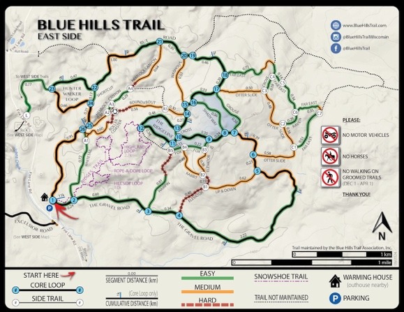
East Side Map for Phone Navigation
Get our East Side Map to use with the FO Maps App

Downloading and using this map for offline navigation...
1 - To get this map, first add the ‘FO Maps’ App to your phone:
- Android phone: open the ‘Google Play Store’ App and search for ‘FO Maps’
- iPhone: open the ‘App Store’ and search for ‘FO Maps’
- Then add (install) the App (FO Maps) to your phone.
2 - Download maps for use with the ‘FO Maps’ App on your phone:
NOTE - download the maps to your phone while you have internet service. Those maps will be available to you when cell service is lacking. Let’s get your map(s):
- Open the ‘FO Maps’ App on your phone.
- Open ‘DISCOVER’ from the main menu.
- Look at the ‘NEAR YOU’ tab to find and download a) the Blue Hills Trail: East Side, and/or b) the Blue Hills Trail: West Side.
- As an alternative to using the ‘NEAR YOU’ tab, look at the ‘ORGANIZATIONS’ tab to find the Blue Hills Trail Association, then download the ‘East Side’ and ‘West Side’ maps.
- The downloaded maps will be available in the main menu under ‘Maps & Projects’.
3 - Use your downloaded maps for offline navigation:
- Go to the main menu, open ‘Maps & Projects’ – and open the map of your choice.
- The screen will show multiple icons that represent navigation tools. If you tap the screen away from the icons, the icons will hide. Tap the screen again, and the icons reappear. Individual tools can be turned off if you don't need them (more on that later).
- The most useful feature is knowing your location. Your location will show as a green dot or a blue chevron. If your location isn't visible, look at the tool options on the right, and tap the small circle with crosshairs. The screen will shift to show your location.

- Another very useful feature is GPS Tracking. The icon for this tool is shown below.

- Play around with the rest of the navigation tools to see which options appeal to you.
- Now take a look at ‘Settings’ in the main menu, it’s at the bottom. Make adjustments to the various parameters as desired. Be sure to look at ‘Navigation Panel’ where you can turn off/on the navigation tools that show on the map screen.
Another useful option for beginning your navigation:
- Open ‘General Map’ from the main menu. It offers another way of viewing the surrounding area – including icons representing the maps you have downloaded. Tap one of those map icons to open the map.
Summary: Get the FOMaps App, open a map, and explore the possibilities. It's a good resource for navigating the Blue Hills Trail where satellites track you even when cell service is lacking.
DISCLAIMER
This map is purely intended to simply estimate your location within the Blue Hills Trail system and to aid you in your navigation of the trails. It is your responsibility to understand the limitations of this map as they relate to your personal navigational needs and to supplement as necessary.
Blue Hills Trail
instagram updates
Subscribe to Newsletter Updates
Stay in-the-know about grooming updates, special events, news, announcements, volunteer days, and more. Rest-assured, we never sell or share your information.


